
square
triangle
circle
rectangle
第1题:
路由器Rl的连接和地址分配如下图所示,如果在Rl上安装OSPF协议,运行下列命令:router OSPF100,则配置SO和EO端口的命令是( )。
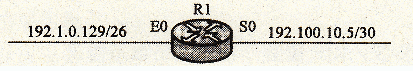
A.network 192.100.10.5 0.0.0.3 area O
network 192.1.0.129 0.0.0.63 area l
B.network 192.100.10.4 0.0.0.3 area 0
network 192.1.0.128 0.0.0.63 area l
C.network 192.100.10.5 255.255.255.252 area 0
network192.1.0.129 255.255.255.192 area l
D.network 192.100.10.4 255.255.255.252 area O
network 192.1.0.128 255.255.255.192 area l
第2题:
The distance between any two meridians measured along a parallel of latitude ______.
A.increases in north latitude and decreases in south latitude
B.decreases as DLO increases
C.increases with increased latitude
D.decreases with increased latitude
第3题:
A、IntegratedIS-IS使用L3路由作为骨干路由
B、骨干网是一个连续的L2或L1/L2ISIS路由器的链条
C、IntegratedISIS路由器属于至少一个area,不需要中央化的骨干area
D、所有的ISIS其他area都必须连集中接到ISIS的骨干area上
第4题:
第5题:
Distance along a track line is measured on a Mercator chart by using the ______.
A.latitude scale near the middle of the track line
B.longitude scale near the middle of the track line
C.latitude scale at the midlatitude of the chart
D.latitude or longitude scale at the middle of the scale
第6题:
A.SITE Name/Longitude/Latitude/Cell Name/BCCH/BSIC/CELL ID/LAC/ AZIMUTH
B.SITE Name/Longitude/Latitude/Cell Name/PCCPCH RSCP/CPI/CELL ID/LAC/ AZIMUTH
C.SITE Name/Longitude/Latitude/Cell Name/BCCH/BSIC/LAC/ AZIMUTH/Hight
第7题:
A Mercator chart is a ______.
A.cylindrical projection
B.simple conic projection
C.polyconic projection
D.rectangular projection
第8题:
A. only summarized routes
B. all routes in the network
C. all routes in the backbone
D. No routes are advertised.
第9题:
The area of strong westerly winds occurring between 40°S and 60°S latitude is called the ______.
A.polar easterlies
B.prevailing westerlies
C.roaring forties
D.jet streams
第10题:
In JUNOS software, how is route summarization at the L1/L2 border configured?()